7 Ways Drone Radar Is Revolutionizing Water Discovery on Mars
Exploring Mars for water is a top priority for future human missions. Access to water ice could provide drinking water, oxygen, and rocket fuel. But where exactly should spacecraft drill? Recent experiments with drone-mounted radar over Earth's glaciers are showing how the same technology could map buried ice on Mars with remarkable precision. Here are seven key insights you need to know about this groundbreaking approach.
1. How Drone Radar Peers Beneath the Surface
Ground-penetrating radar (GPR) isn't new, but mounting it on a drone adds a whole new dimension. Traditional GPR is limited to small areas and often requires direct contact. A drone can fly over rugged terrain, sending radio waves into the ground. These waves reflect off different layers—like ice, rock, or soil—and return to the drone, creating a detailed subsurface map. In tests over alpine glaciers, the drone radar could detect buried ice layers as deep as 50 meters, distinguishing between solid ice and rocky debris. This capability is crucial for Mars, where surface conditions vary wildly from frozen plains to windblown dunes.

2. Why Water Ice on Mars Is So Hard to Find
Mars is a dusty desert with a thin atmosphere, but it harbors vast quantities of water ice—much of it hidden beneath a layer of regolith. Orbital instruments like MRO (Mars Reconnaissance Orbiter) have identified large icy regions, but their resolution is too coarse for pinpointing drill sites. The ice can be buried under several meters of dry soil, mixed with rocks, or exist as pure sheets. Without fine-scale mapping, a lander might drill into solid rock or miss the ice entirely. Drone radar flown on Earth directly addresses this challenge, allowing scientists to simulate Martian conditions and refine detection algorithms.
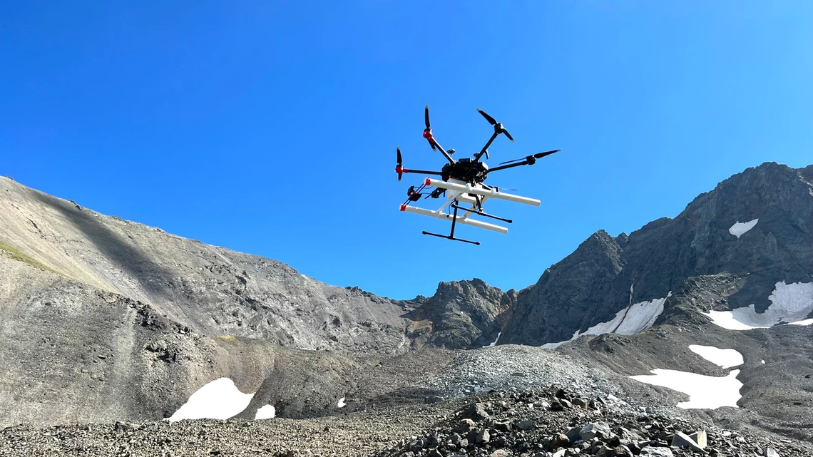
3. Earth's Glaciers as a Perfect Test Bed
To prove the concept, researchers took drone radar to Earth's glaciers—specifically in the Swiss Alps and Iceland. These environments mimic Martian polar and mid-latitude regions where ice is expected. The drone flew at low altitudes (10-30 meters) and collected high-resolution data over rugged terrain. The results were striking: the radar clearly mapped ice thickness, internal layers, and buried crevasses. By comparing these data with known ice boundaries, scientists validated the accuracy of the method. This is the same blueprint they plan to adapt for a future Mars mission.
4. Pinpoint Accuracy: From Kilometers to Meters
While orbiters can spot ice-rich areas across hundreds of kilometers, they can't tell you exactly where to put a drill. Drone radar, by contrast, achieves meter-scale resolution. In the glacier tests, the system could identify ice pockets only a few meters wide. For a spacecraft landing on Mars, this means selecting a safe, ice-rich location within an otherwise barren landscape. The drone's ability to fly low and slow allows it to cover large areas efficiently, creating 3D maps of the subsurface. Future Martian drones—like helicopter designs—could do the same.
5. The Critical Role of Autonomous Navigation
Operating a drone on Mars is no easy feat. The thin atmosphere and communication delays demand near-total autonomy. The Earth-based tests used pre-programmed flight paths, but researchers are developing AI that can adapt in real time—avoiding obstacles, adjusting altitude, and analyzing radar returns on the fly. This autonomy will be essential for a Mars drone to survey wide regions without constant human input. The radar itself must also be lightweight and energy-efficient. The drone flown in the Swiss Alps weighed just 10 kilograms; a Mars version would need to be even more robust.
6. Beyond Water: Detecting Ice Purity and Structure
Not all ice is equal. Some Martian ice may be mixed with dust or permafrost, which affects its usefulness. The drone radar can differentiate between clean ice, debris-rich ice, and solid rock by analyzing the radar wave reflection patterns. In glacier tests, the radar identified layers of varying purity—information that tells scientists if the ice can be melted for drinking water or easily processed for fuel. This level of detail goes beyond just finding water; it characterizes its quality, which is vital for mission planners.
7. The Road Ahead: From Earth to Mars
The next step is to scale up. Engineers are working on a Mars-specific drone radar system that can withstand the planet's extreme cold and low pressure. NASA's Ingenuity helicopter has already proven that powered flight is possible on Mars. Future missions like a “Mars Science Helicopter” could carry radar payloads. The drone radar concept is also being considered for lunar ice exploration. By refining the technology on Earth, scientists are building confidence that a drone mission to Mars can deliver the high-resolution maps needed to choose drill sites—potentially within the next decade.
Conclusion: Drilling Deeper, Smarter
Finding water on Mars is a race against time and distance. Drone radar offers a smart, efficient way to survey the surface before drilling. By testing over Earth's glaciers, researchers have shown that the technology can reveal hidden ice with stunning clarity. The next generation of Mars rovers and landers may not rely on luck alone—they'll have a drone’s-eye view of what lies beneath. This marriage of aerial mobility and subsurface sensing could be the key to unlocking Mars’ frozen secrets and enabling human exploration.
Related Articles
- Navigating the Ransomware Landscape: A Practical Guide to Q1 2026 Trends
- Gravitational Lens Reveals Quintuple Supernova, Promises to Solve Hubble Constant Puzzle
- The Brain's Built-in 'Stop Scratching' Mechanism: New Research Reveals a Molecular Brake for Itch Relief
- How I Set Up a Personal Cloud Workspace at Home Without the Headache
- AI ‘Scientists’ Zero In on Drug Repurposing: Google and FutureHouse Unveil Agentic Research Assistants
- 10 Breakthrough Insights into Reversing Type 1 Diabetes with Lab-Grown Insulin Cells
- The Location of Your Sense of Self: How It Shapes Your Life and How to Shift It
- The Field Guide to Particle Physics: Why Physicists Love Fields